Republic of Ambazonia Official Website

Our Blog

Warning

This article or modules on this page were created by a demo user account which is no longer in existence.
Please edit the article and assign a new user

Mount Fako

Features of a Beautiful Land


It is seen here erupting for the sixth time this century in March 1999.


A beautiful sun-setting view of the Chariot of the gods from Victoria’s Atlantic Ocean beach
 
 
Tourists climbing Mount Fako
A beautiful view of Mount Fako


Being the highest mountain in West Africa, Mount Fako is a majestic volcano which dominates the region offshore; an impressive necklace of islands is scattered over the waves. After relaxing on the beach, prawn kebabs grilled on an open fire will delight you. The volcano of Mount Fako, which is still active, dominates the region of Victoria from its height of 4,100 metres (13,500'). The tops of the mountain of this whole region, which is often compared to the Auvergne, are rounded by ancient craters. The last previous eruption was in 1982 during the filming on the mountain of Greystokes: The Legend of Tarzan.


Each year a race is held on Mount Fako, where competitors, who arrive from all over the world, run up and down the mountain. The best time to date is about 4. 45 hours, and Ambazonians have been invincible so far. Tourists can climb the mountain by arrangement. They usually climb to about 900m below the summit the first day, then reach the top the next morning, and descend in about three hours. Only sports gear is required, but it can be very cold near the top (over 13,000 feet). Climbers should take a bottle with a message in it, to leave at the summit. Also be wary of stone throwing monkeys, and please do not souvenir anything from the mountain - it would be offensive to the local people, and bring the ire of the mountain gods. It is truly an inspiring spectacle.

In the last century, a number of aircraft on approach to Douala in neighboring Cameroon have crashed into the mountain, the last being in 1963, when a DC 6 hit the mountain with the death of 44 on board. The aircraft still juts out of the side of the mountain as a permanent memorial to the crash victims. The mountain is held in awe by the local villagers, and it is believed that an eruption is caused by either the death of a chief, or the presence on the mountain of outsiders. The scientific explanation holds little credibility in the region. By coincidence a chief has died prior to the last two eruptions, reinforcing tribal beliefs.

From the foot of the mountain to the summit and distantly to the valleys are romantic regions of varied scenery which invite discovery and exploration. Mount Fako itself is a restful and refreshing place. The peaceful indigenes here are the Bakweri who offer great hospitality to visitors. They are ruled by a paramount chief in the person of Chief SML Endeley. With the scenic beauty, climbing Mount Fako is enjoyable because of its great attractions. Mount Fako is an easy mountain to climb. There is no doubt that a tour of Mount Fako offers something to suit all tastes-rest, relaxation, and excitement.

Welcome to the Summit of West Africa:

Upper farms to Hut One
A tourist would enjoy seeing the old dairy prison department farm of Upper Farms Buea. Before entering the forest a glance behind allows you to see the scenery and settlement of Buea Town, which was the ancient colonial capital of the German Kamerun. As the visitor starts climbing the Mountain all around is the Mountain rain forest. Inside the forest you will be attracted by varieties of beautiful birds. An example of such beautiful birds, the Mount-Fako Francolin “KWAI” can only be seen on the slopes of the Fako Mountain and nowhere else in this world.

You may be lucky to come across monkeys of different colors (like the red-eared monkey) if you randomly enter the interior of the forest. This monkey has a red tail, a red spot on its nose and red tipped ears. Also chimpanzees which are very intelligent and closest to man in terms of behavioral pattern are also found in the forest of Mount Fako. In the Bakweri and Bomboko tradition chimpanzees are not hunted. The elephant (Njoku) is also found here, which is the largest animal in the forest of Mount Fako. It is advisable to trek gently so as to enjoy your tour. The indigenes of this Mountain, the Bakweri farm basically coco-yams which you will notice, are grown as you ascend. The distance from Upper Farms to Hut One is 785 metres.

Hut One
A cold flowing spring welcomes the visitor to Hut one. This spring could be used for a variety of purposes by the tourist. Here he or she could rest and take few snap shorts. You are now 1875 metres above sea level. Crossing the forest to the Savanna region would take a person 43 minutes. And along the road you will see dry valleys with trees very tall some of which are more than 20 metres high. After a long walk across a dry valley you will notice a distinct change of vegetation, from very tall trees to just ordinary grass.

Savanna zone
The savanna zone is of a steep and rocky gradient covered with grasses which are sometimes as high as 1.5 metres. It’s completely void of tall trees. The trees around here are scanty and short. Climbing up you will see the rain gauge and the famous lonely tree (Magic Tree). A distant sight-seeing will expose the eye to the very deep and long valleys. Also the presence of valleys and crests make movement in this area extremely difficult.

Hut Two
This is 2860 metres above sea level. The scenery of the Fako Mountain is very visible here. The tourist will see the rocky undulations of valleys and crests. Just five minutes’ walk in front of Hut two you will find a big blow-hole. A guarded tour takes one through huge Caverns; one high enough like a warehouse. Inside the caves you will find geological features like Stalagmites and Earth Pillars. The temperature at night is between 50C - 90C. You can pass the night here at Hut two and leave very early in the morning for Hut Three.

Hut Three
Along the track to Hut three, the trekking should be done gently as you will find some beautiful flowers, getting to this point is between 3740 metres high and temperature is between 40C - 20C. This is the last Hut up the mountain. Here it is advisable to rest for a short while so as to eat some food and drink some water before continuing to the summit. This touristic scenery makes Hut three one of the most attractive sites given by the Almightily God to Ambazonia.

Summit
A walk form Hut three to the summit is particularly attractive. This is a part of untouched nature known for its fresh, clean air, blowing as you climb to the summit. Here the summit breeze helps you to forget your dull every day routine and all melancholic thoughts are dispelled. You will notice a short distance of level land and black fragments of sandy nature. This wonderful scenic region offers the tourist exceptional vegetation covered with grassy, tree-free terrain with patches of ramified 2 centimeter greenish plants. By the time you get to the summit the coldness and heavy breeze welcomes you to a new climatic world. To enjoy your two day tour to Mount Cameroon, come to Buea a day before and spend the night in our hotels.

Mount Fako Race of Hope
This is a yearly event that started from 1973 by Guinness Cameroon S.A. Today excellent mountaineers break the hearts of observers. Rev. Father Walter Stifter, Amos Evambe Ndumbe, Timothy Leku Lekunze (late), Walters Ekonde, Reginald Esuka , Queen of the Mount Fako Sarah Liengu Etonge and many others come and see runners from Molyko stadium to summit and back.

Eruption of Mount Fako
Successive eruptions of Mount Fako took place in 1909, 1922, 1954, 1959 and 1982. The indigenes at the foot of Mount Fako, the Bakweri hold the traditional belief that the eruption of 1982 took place because of the death of the late paramount chief H.R.H. Gervasius Mbella Endeley. The eruption started immediately after he was buried. Today his palace and grave-site attract tourists visiting Mokunda, Buea.

Since then the mountain has been calm, until recently in 1999 that the mountain erupted welcoming the third millennium as it also erupted in the year 2000 confirming what we can refer to as an active volcanic mountain with the lava flowing to west coast of Cameroon, leaving behind layers of rocks of various colors and textures, craters, vast ecological destruction etc. This site is an attraction to both national and international visitors.

Other attractions within Mount Fako region are:

  • Water fall at Bomboko.
  • Crater Lake at Idenau.
  • Eruption site of 1999 at Bakingili.
  • Ecological disaster of 1922 eruption along Idenau Coast.
  • Traditional dances of indigenes at the foot of Mount- Cameroon.
  • Elephant dance.
  • Animal killing (Motiyo).
  • Lingombi dance.
  • Cha - Cha dance.
  • Agro-tourism plantations - Tole tea, Molyko Banana, Tiko Rubber and Bota palms. 

Ecotourism sites include:

  • Bomboko Elephant site.
  • Ekona Lelu Forest and 1954 Lava Flow.
  • Mapanja pigiun African rain forest and Safari.
  • Victoria Zoo and Botanic Garden.
  • Nyango na Muna Rocky Twin Stone.


Read more...

Menchum Falls

Menchum Falls is a very beautiful touristic site and has the capacity to produce electricity for all the countries in the West African Region.

The pictures below show a clear aerial view of this great product of nature currently under utilized.


River Menchum seen just before it cascades as the Menchum falls a little distance downstream on the right.

Read more...

Korup National Park

Introduction:

Korup National Park (KNP), located in Southern Region of Ambazonia, covers 126,900 hactars of forest, most of which is evergreen forest. The forest has never been logged. The park was created in 1986 and includes the former Korup Forest Reserve, established under British mandate in the 1930s. It is now under the colonial administration of the Department of Wildlife and Protected Areas in the Ministry of Environment and Forests (MINEF). Korup became part of the TEAM Network in 2011.

Korup is located 60 km inland from the Atlantic Ocean, and 10 km from the border with Nigeria. It is 5 degrees above the equator. KNP is one of the wettest and most isolated remnants of the Atlantic coastal forest that once spread all the way from the Niger delta to Gabon. The climate is pseudo-equatorial and very wet, with 5300 mm of rainfall annually. The area has a distinct dry season in December-February and an intense wet season from May-October. Rainfall is heaviest in August, and can exceed 1000 mm.
The park has sandy soils that are very poor due to nutrient leaching by heavy rainfall. Very large granite boulders are typical for the park and form tourist attractions.
Korup is home to the 50-ha Korup Forest Dynamics Plot (KFDP) with 494 tree species, and is part of the Center for Tropical Forest Science network, in which all trees with a diameter at breast height exceeding 1 cm have been mapped, tagged and identified, and are measured every five years. Korup had wildlife censuses and human-wildlife conflict studies.

Site Description:

The Korup National Park has a number of camps, two of which harbour scientists. The camps are in the phase of rebuilding, as all buildings were destroyed by villagers in 2008 in a conflict over poaching. The TEAM project operates from the Chimpanzee Camp. The current facilities are very basic, with partial housing in tents. There is no electricity and all materials have to be carried to the camps by porters.

Furthermore, an office with storage space and limited visitor accommodations is available in Mundemba, 10 km driving from the park’s border.

The park has an extensive, well-maintained trail system.

Ecology:

Korup was part of a Pleistocene refugium. The forests are very ancient, rich in endemics, and highly diverse. The forest canopy is generally 15-25 m tall, with emergents up to 50 m tall. A typical large tree, second-most common in terms of basal area, is Lecomtedoxa klaineana with huge boles and impressive buttresses. One unusual characteristic is the abundance of small, unbranched trees with large leaves placed in terminal rosettes that trap litter.

Species:

At least 326 species of birds are found in and around Korup, including hornbills and the IUCN-listed red-headed rockfowl (Picathartes oreas) that nests below large boulders. The park has over 40 species of terrestrial mammals. These include four species of duiker: blue duiker Cephalophus monticola, bay duiker Cephalophus dorsalis, Ogilby’s duiker Cephalophus ogilbyi and yellow-backed duiker Cephalophus sylvicultor. Korup National Park contains 15 different primates including endangered species such as the drill Mandrillus leucophaeus, the highest-ranked primate in Africa for conservation action (Oates, 1996). Korup National Park also supports key populations of chimpanzee Pan troglodytes, the distinct subspecies of red-eared monkey Cercopithecus erythrotis camerunensis and the only confirmed population of Preuss’s red colobus Procolobus preussi (Oates, 1996).Forest elephants and chimpanzees are seen occasionally. Leopard is locally extinct or extremely rare.

Korup has experienced intense poaching in the past, which has caused drastic declines of mammal populations. Forest elephants were hunted almost to extinction in the 1960s and 1970s. Poaching has been reduced to moderate levels with the creation of the park and anti-poaching programs. Animal abundance also remains naturally low because of the forest’s low productivity.

View the mammals and birds species list for this TEAM site.

Accessibility:

Access to Korup is from the isolated village of Mundemba, which is located 5 hours driving from Buea, and about 6 hours from Douala International Airport. The road to Mundemba is in poor shape, and access can be very problematic in the wet season, especially in July-November. Access to Korup National Park is via 10 km of dirt roads through extensive oil-palm plantations, and passage of a large suspension foot bridge across the Mana river. It takes 10 km of hiking to get to Chimpanzee Camp from the Mana bridge.


Location

Ambazonia
Latitude: 5.07389
Longitude: 8.85472

Source: http://www.teamnetwork.org/site/korup-national-park


Read more...

Botanical garden

The City of Victoria has a Botanical garden which is the second best in Africa. It plays host to numerous specie of flora of which about 150 of the plants species cannot be found in any other part of the world. The Garden was founded by a group of Germans under the Directorship of Paul Preus in 1892. It served as a trials and acclimatisation centre for the introduction of exotic crop species such as coffee, cocoa, rubber, oil palm, banana, teak and sugar-cane for distribution within "Kamerun" and other German colonies. In its heyday the Victoria Botanic Garden was said to be one of the most important tropical botanic gardens in the world. To complement the work in Victoria, experimental plots for high elevation species such as tea (Camellia sinensis) were established in Buea. The Garden possessed a herbarium, laboratories, classrooms, a museum, a library and staff accommodation.

The British took over the responsibility for the Garden in 1920, advised by the Royal Botanic Gardens, Kew, and it was managed by a Kew-trained Superintendent. The British departed in 1932 and the garden was directly managed by Cameroonian personnel until 1958. With the independence of West Cameroon in 1961, the curation of the Garden was taken over by the Government. Despite the efforts of many people, the Garden declined during this period.


Read more...

Touring Ambazonia

GEOGRAPHY

Ambazonia by virtue of its geographical position in Africa disposes considerable tourist potentials, which make her the place to visit. Ambazonia possesses impressive tourist resources, her relief climate, fauna or flora as well as people and traditions. As home of the highest peak in West Africa and land of the great Menchum Falls, (which scientists say it has the capacity to supply enough electricity to the entire West African Region) Ambazonia offers equally as many traditions as cultural diversities.

Ambazonia is made up of two geographical regions: the Grassland region to the North and the Forest Region to the South. Ambazonia overflows with enormous tourist riches, various natural geographic curiosities, historic vestiges living testimonies of what had existed in the country, a cultural heritage, traditional characteristics of every people that she represent, exhibitions and other folkloric events as varied as its people.


Grassland Region


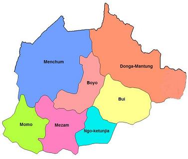
The Grassland Region, located to north of the territory has a population of about 4,750,930 inhabitants with a surface area of 17,300 square kilometers. Its population density is approximated at 98.41 inhabitants per a square kilometer. With seven (7) administrative Counties (Bui, Boyo, Donga-Mantung, Menchum, Mezam, Momo, and Ngo-Kentunjia), the region is hilly & mountainous with beautiful grass-field landscape, variety of traditional palaces, waterfalls, crater lakes, handicraft shops and abundant artifacts which make it the citadel of the nation’s rich culture. Totally neglected by the annexationist colonialist regime of Yaoundé, the Grassland Region has no major industrial plant, and the only relatively flat area is the Ndop Plain where rice is grown. There are equally a variety of languages spoken by its beautiful people. The main languages are Bafmen, Oku, Lamso, Bamenta, Pinyin, Balikumbat, Mankon, Wimbum and Nkom. There are nine hotels, seven restaurants & two night clubs of international standard. Seven large tribes dominate the region: The Nso, Wimbum, Meta, Kom, Esimbi, Oku & Menda-Nkwe people.

Climate
There are two seasons:
A dry season beginning from November and ending around May. The average temperature is about 20°c the air is dry and cold.
A rainy season that begins in June and ends around October. In the day the average temperature is about 20°c and 15°c at night.

Relief
Bamenda is surrounded by several mountainous ranges and deep valleys. The valleys are generally covered by raphia and eucalyptus. Raphia is a basic raw material for the fabrication of art objects. It is also used in the production of raphia wine appreciated by visitors of the region.
 

Touristic Sites

Mezam County:

  • The Awing crater lake
  • Press-craft center of Bamenda
  • Handicraft center of Bamenda
  • Rocky mountain chain of Sabga
  • Many small water falls at up station
  • The Bafut palace, the Bali palace
  • The Bali press craft workshop
  • The Mbantu shrine
  • Snake research center of Bali
  • Cold hill at Bafut
  • The German cemetery in Bali
  • Salt springs of Sabga 

Ngoketunjia County:

  • The Baba plain
  • The Bamungo palace (one of the most beautiful Chief’s palace), the cradle of all the traditions of the region
  • Mount Wainamah, 2, 500m from its peak (the Bamendjon Dam can be observed)
  • The Bamessing fish station
  • The Bambalang palace 

Boyo County:

  • The Laikom Palace, 79km from Bamenda
  • The German palace, 72km from Bamenda
  • The Mbi crater cave and game reserve at Fundong, 78km from Bamenda
  • Lake Kuk of Bafmen
  • Ejim Trust Reserve of Bello, 45km from Bamenda 

Momo County:

  • The Abbi waterfalls in Mbengwi
  • The Falls of oshie
  • The Mbengwi monastery
  • The Oshie palace
  • The Guzang Fon’s palace
  • Itipanghi (Widikum Ancestral Site in Azem Clan)
  • Ambelle Boulder
  • Gonikob (Scenic rocks in Ngwenjin-Azem Clan)
  • Dudum Falls in Akuwu
  • Tadkon Historical Site
  • Ambelle Ette-Begout Mountain and Caves
  • Abebung historical home of Abendong
  • Abegum Fon's Palace

Menchum County:

  • The Menchum Falls at 65km from Bamenda
  • The Kimbi Forest Reserve with its fauna rich in several animal species (antelopes, chimpanzee, gorilla etc)
  • Lake Nyos
  • Lake Wum (the Silent Lake) 

Bui County:

  • The Nkar palace
  • The Kumbo Cathedral constructed entirely with stones
  • The Oku Honey and Handicraft reserve
  • The Kum town, built on several hills, a site favorable for curative tourism and for mountain tourism
  • Lake Oku
  • Kilum Mountain

Donga-Mantung County:

  • Binka village situated on the hills about 3,000m high with several cattle ranches
  • The Ndu Tea plantation
  • The artificial lake of Binshua
  • King’s rock of Nwa
  • Kwe Athombo cave at Nkambe
  • Iron Ore at Nwa
  • Binkar landscape and cattle market
  • Rom Rocks of Nwa
  • Ndu Palace
  • Tabenken Valley
  • Mbaw plain


Forest Region


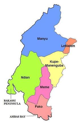
The Forest Region, with a population of about 2,243,125 inhabitants, has a surface area of 25,410 square kilometers. Made up of 6 administrative counties (Fako, Kupe-Manengouba, Manyu, Meme, Ndianand Lebialem counties) with a total population density of 45.38 inhabitants per a square kilometer, the region is the home of Mount Fako which is the highest mountain in West Africa (with a height of 4,100 meters). With a very rich and attractive colorful coastline with numerous beaches, the Southern Region is the home of the Korup Park, situated in Ndian County and home of a wide variety of trees and rare animals. 

Climate:

There are also two seasons in the Forest Region: Two distinct dry seasons, in which the most important one is short at the coast, lasting from November-February, and the shorter dry season lasting for two months, December-January. A rainy season that begins in June and ends around October with a monthly total at 90-150 mm. 

Relief:
The highest point of the region, and also the highest point in Ambazonia, is Mount Fako (4, 100 m), situated (4°12'N/9°10'E) on the coast. In the mountains along the western border there are two distinct dry seasons. The most important one is short at the coast and increases in severity in passing inland, where it may last for 4 months from November-February, for instance at Mamfe (5°46'N/9°18'E) and Bamenda (5°55'N/10°09'E), where these months are virtually rainless. At Tiko (4°02'N/9°19'E) on the coast, this dry season is much shorter, lasting just two months, December -January. The second dry season is much shorter and is far less severe, but is seen in a sharp diminution of rainfall during June-July, when the monthly totals are in the region of 90-150 mm at all three stations.

The coast enjoys a per-humid equatorial climate. At the coast the border with Nigeria is defined by the course of the small Akpa Yafe River, which reaches the sea through a mangrove swamp 35.5 km deep between landward and seaward faces. This forest block, intersected by the Rio del Rey, Ngosso and Andokat Estuaries, stretches 57 km along the coast until it is interrupted by the slopes of Mount Fako which descend steeply into the sea. This great mangrove block, covering 145 000 hectares, has developed on the deltaic coast created by hundreds of small streams draining the very wet slopes of the Fako Mountain and the Rumpi Mountains immediately to the North East. The canopy of the mature Rhizophora forest reaches 45 m in height, and freshwater tidal swamps occur at the back of the mangroves in places, e.g. 70 km upstream on the Moko River which discharges via the Andokat Estuary.

The Forest Region has a very rich relief that starts from the east of the Mungo River (official eastern frontiers with Cameroon) with the vast Tiko Plain, running towards the north-west with volcanic and beautiful Mount Fako , and the mangrove swamps that stretches from the sea at Tiko to parchments of the Atlantic Ocean in its western borders with Nigeria. There is also a vast and rich forest that extends between four counties – Kupe-Muaneguba, Lebialem, Manyu, and Meme. It is home of Debunscha, situated on the north-west of Victoria, and the second wettest place in the world after India’s Cherapunji. Debunscha has an annual rainfall of 10, 000mm. 

Touristic Sites:

Fako County:

  • The Victoria Beaches
  • The Jungle Village
  • The Atlantic Hotel sharing boundary with the Atlantic Ocean
  • Tole Tea Estate
  • Botanical Garden and the jungle village, constructed during the colonial era by the English. It is the second in Africa after that of Kenya.
  • The Victoria Zoo. It is of re-creative aesthetic, scientific or cultural interest and regroups wild animal species, which constitute sufficient seduction to visitors. Amongst the mammals found there are: the mandrill (Pan Troglodytes). The reptile population is represented by African crocodiles and pythons.
  • The Fishermen’s Village
  • The Islands of Bota, Mondoli, and Ndame.
  • The Mile six beach
  • The Tomb Stones of foreign fallen legion officers
  • The Lava flow of Bakingili
  • The Alfred Saker Monument.
  • Mount Fako (4, 100m) also known as the Buea Mountain is an attractive volcano but easy to climb, hence the large scale organization of its ascension annually regrouping athletes from many nations of the world. Founded in the 6th century before Jesus Christ, the ‘Chariot of the gods’ is an ecological site of rare fauna flora. The last two volcanic eruptions of 1999 and 2000 did not succeed in dredging the well kept plantations in the dense forest, the grass savannah and the prairies, which you will go through if you decide to cover the 4 100m climb. A peak of ash and solidified lava; a true place for purification, retreat, camping, trekking and discoveries.
  • Palm oil, pepper, and tea plantations at Tole
  • The Muea market
  • The Buea Handicraft Center
  • The Virgin Forest at the foot of Mount Fako
  • Solidified lava from the 1999 volcanic eruption
  • The residence of Von Puttkamer
  • The Botanic Garden of Mile 17. 

Kupe-Muaneguba County:

  • The Kupe Mountain with Mount Manengouba (2, 050 meters high)
  • Muaneguba Twin Lake 

Manyu County:

  • The Hanging Bridge on the Manyu River
  • Lake Ejagham
  • The Cross River
  • Bakogo Waterfall
  • Ikom Waterfall 

Meme County:

  • Lake Barombi Mbo
  • Lake Barombi Kang
  • Lake Barombi Koto
  • Lake Soden
  • Lake Fiango (a basin lake) 

Ndian County:

  • The Korup Park (one of the largest wildlife reserves in the world)
  • River Ndian 

Lebialem County:

  • Lebialem Waterfall


SEA SITE ASPECT

Open to the Atlantic Ocean, Ambazonia offers to beach and sea amateurs an extensive coast. Colorful bays, natural beaches with gold colored sand in Victoria, mangroves, waterfalls and cascades emptying directly into the sea. That makes a very pleasing program for a tourist stay. Also, within the country, the enormous lakes reflecting the colors of the beautiful solar system are one more spot for sun bathing, water bathing and diverse distractions.

AGRICULTURAL ASPECTS

In the domain of agro tourism, the diversity of agriculture is found through plantations and agro industrial units. The Commonwealth Development Corporation (C.D.C) is the largest agro industrial unit in Ambazonia with impressive Banana, Tea, and Palm Oil Plantations. You could visit the Tea plantation in Tole (Buea) and Ndu; Banana plantation in Delmonte in Tiko. There is also the PAMOL Oil Plantations in Ndian County. They are magnificent vast greeneries and exploitation of high revenue to the economy of the territory. Still in this domain, you will discover the beautiful Cocoa trees striking in their sizes, their cherries, their shapes and in their alignment. You could equally appreciate the diversity in Ambazonia agriculture in the Northern region. It is a good opportunity finger plants giving Irish potatoes, beans, maize, cabbage, pepper, green pepper, tomatoes, cassava, okra, onion etc.

CRATER LAKES

Lake Barombi Mbo (4°39'N/9°24'E) has an open water area of 453 hectares. The lake surface used to be at an altitude of 301m asl, but this has been raised artificially. The lake now has a maximum depth of 111 m and a mean depth of 69 m, and contains 11 endemic species and 1 endemic subspecies of fish. Lake Barombi Koto is situated 25 km SW (4°28'N/9°16'E) and covers 330 ha at 110 m asl. It is an important sanctuary for birds and contains one endemic species, and also one endemic subspecies of fish. Lake Soden (4°43'N/9°17'E), c. 360 that, is 15 km NW of Lake Barombi Mbo. Lakes Alangani (6°05'N/10°21'E) and Oku (6°11'N/10°28'E) are situated farther north in the high mountains. They both have areas of about 315 ha and are 2002 and 2019 m asl respectively. Mt. Oku close by rises to an altitude of 3011 m asl. Lake Nyi (6°25'N/10°13'E) farther north is smaller (Trewavas (1962; 1974), Trewavas et al. (1972) and Corbet et al. (1973).


Read more...

Talk to us

085 888 5555